

The Eskey System: A Model for Lunar Addresses based on Low Slope Routes and Quadrangles
Megan Eskey created a framework for planetary addresses based on quadrangles and low slope routes. The Eskey System is considered to be the first and optimal model to date for planetary addresses based on a system of roads. It uses current International Astronomical Union (IAU) nomenclature guidelines as the inspiration, and defines the syntax based on widely accepted and adopted cartographic elements. Read more in the Grand Strand Astronomers’ monthly newsletter, the Astrogator.
Her work was first presented at the Interplanetary Infrastructure session at the 2024 International Space Development Conference (ISDC). Slides are available on SlideShare and the recorded talks are available on YouTube.

This cover was canceled on the Moon by astronaut Dave Scott on August 2, 1971, during the Apollo 15 mission. It carries two advance, hand-perforated die proofs of stamps celebrating the U.S. space program. Smudges at the bottom left are believed to be “thumbprints” Scott made with moon dust using his space-suit glove. Courtesy of the United States Postal Service
The Eskey System defines a methodology for charting lunar roads using optimal landing sites and other points of interest, and extends the model to Mars. Other planetary bodies such as Venus and Mercury also have associated quadrangles with provisional or approved names, but don’t have environments that lend themselves well to building transport routes.

Historic footage of Apollo 15 commander Dave Scott canceling the Apollo 15 cover.
Transcript of Video
Dave Scott: To show that our good Postal Service has deliveries any place in the universe, I have the pleasant task of canceling, here on the Moon, the first stamp of a new issue dedicated to commemorate United States achievements in space. And I'm sure a lot of people have seen pictures of the stamp. I have the first one here on an envelope. At the bottom it says, "United States in Space, a decade of achievement," and I'm very proud to have the opportunity here to play postman. I pull out a cancellation device. Cancel this stamp. It says, "August the second, 1971, first day of issue.” What could be a better place to cancel this stamp than right here at Hadley Rille? By golly, it even works in a vacuum.
The methodology lays the groundwork for multiple use cases, including applying the lunar post roads towards determining territorial boundaries on the Moon, similar to the deconfliction “safety zones” as defined by NASA’s Artemis Accords. Post roads could be utilized to resolve territorial disputes, and unlike safety zones, are permanent in nature and have legal precedents on earth.
Similar to the Trump Administration’s Chapter 8 in the 2020 annual report by his Council of Economic Advisers (CEA), the framework approaches the boundaries of the international space treaties without crossing them. Legislation to provide private space miners rights to the natural planetary resources could imply the same rights for the private planetary roads.
“Frameworks such as the U.S. Commercial Space Launch Competitiveness Act and the Artemis Accords enhance property rights by providing clear expectations of the benefits one can receive from their investment and providing a list of principles that partner nations will follow as a way to encourage economic activity in space.“
- Chapter 8, CEA 2020 Annual Report, January 2021

On August 30, 1983, the space shuttle Challenger blasted off on its third mission to space. The shuttle carried special cargo – 260,000 commemorative postal covers bearing the new $9.35 Express Mail Next Day Service stamps.
Megan Eskey is the originator of OpenStack, an open source software release by NASA and Rackspace in 2010. Her design for OpenNASA v2.0 provided the inspiration to the Nebula cloud computing team. After studying her architecture, Nebula shifted resources from a hardware-based model with servers configured in a shipping container, to an open source model that included one of her components, also named Open Stack. Her team was one of the first at NASA to bring open source into the agency, standing up a WordPress intranet called InsideAmes in 2007. Quantum Geographic Information System (QGIS) is an open source mapping solution that provides one of the best platforms for making the first lunar maps.
Megan Eskey was the NASA Ames rep for a web registry called the Agency Web Registration System (AWRS) and has used that software as a model for her conceptual architecture, which consists of a planetary road registry connected to a network of rover route mapping software companies such as Skycorp. Route mapping software can be enhanced by taking into account the fractal structure of most lunar features, where the perimeter around some lunar landforms changes by an order of magnitude depending on the distance scale.
In terms more familiar with the internet startup community, Reloquence is building and scaling a 2-sided marketplace that matches cartographers with brands such as space mining professionals and gaming companies to commission or license maps with a shared copyright.
“We find that most of the lunar surface exhibits fractal behavior over the given scales ranging from 1 to 256 m. Lunar maria have higher fractal dimensions than other geological units, while those of volcanic areas and highlands are lower than their surroundings. Simple and flat surfaces have low values of similar ratios and these areas indicate low surface roughness and young ages. Older-aged areas, such as the Hertzsprung basin, have low fractal dimensions and high similar ratios by their complicated topography.”
- The Fractal Nature of Planetary Landforms and Implications to Geologic Mapping, Stuart J. Robbins, Earth Space Sci. 2018 May; 5(5): 211–220.
“Rock and liquid water on Earth, frigid water-ice and liquid methane on Titan - it makes little difference. Their mutual interactions are the same, and so we see geology repeating itself on different worlds, with the same fractal structures. “
Credits: The Five Most Impressive Geological Structures in the Solar System, David Rothery, The Conversation, August 23. 2021
Like a telescopic steering wheel, the planetary roads can help sky watchers and rovers navigate the complexity of the planetary landforms, avoiding steep craters and other barriers on the path.
In her early career, Megan Eskey implemented a constraint-based scheduling system during her tenure with the planning and scheduling group in the AI lab at NASA Ames. Today, systems like SEXTANT at MIT and GRTOP at the University of Arizona leverage similar technology to map sophisticated rover traverses using parameters such as total cost, solar power consumption and illumination to quickly and accurately generate traverses that are simultaneously optimized for numerous constraints, including the lowest number of deployment steps, the shortest traverse based on 3D Euclidean distance, the smoothest traverse with respect to terrain roughness, the least altitude change, or any combination of these.
Megan Eskey is the first to define a field of study called “space roadbotics,” and has written an executive report that puts her framework into the context of real-world use cases such as traversing caves and canyons on Mars, and the Apollo 15 mission, which included the first manned rover on the Moon and was the first road trip in space. A space logistics platform coordinating an international fleet of roadbots could be viewed as something akin to “Uber Space,” with the goal of building a network of transport routes for space mining or human settlements on the Moon and Mars.
Please get in touch if you would like a copy of the white paper, which defines the syntax and names the first 5 roads in space, and the executive report, which includes an appendix linking the lunar landing sites with a system of roads.
Apollo 15: In the Mountains of the Moon
This video features the following: (1) extra vehicle activity (EVA); (2) the three traverses of the lunar surface; (3) film taken from the Lunar Rover; (4) hammer and feather tests of Galileo's theory on falling objects in gravity fields; (5) Worden's EVA; (6) subsatellite launching; (7) X-ray pulsar observations; and (8) splash down with one parachute collapsed.
Megan Eskey is a graduate of the University of Southern California, with a B.S. in Mechanical Engineering and an M.S. in Computer Science. She was trained at the NASA Academy of Program and Project Leadership (APPL). Her early-stage, pre-revenue startup, Reloquence, launched from the San Diego chapter of Founder Institute, an accelerator for investible, scalable C Corps.
To date, 32 US roads have been named and localized as a nod to the 32 Apollo astronauts, including Wingo Epps Circle, the first road in space. Heller Eskey Highway, the second road in space and the first highway, was named for a collection of 8 unpublished short stories written in the early 1950s by her father, David Eskey. His editor was none other than Joseph Heller of Catch-22 fame. Her tentative title for the book is A Perfect Catch: The Dave Ellas Series.
"Jack was back on the chair legs again, picking up the trio’s last chords. Carl managed to catch Rudy’s eye when the music stopped, and gestured toward the ceiling with his hand. Rudy nodded, grinning whitely, and said something to Jay and Tony.
Tony reached over and picked up his brushes, following him into the melody, and Rudy sang,
“Somewhere there’s music, How faint the tune? Somewhere there’s heaven, How high the Moon?”
At the first sound of Rudy’s saccharine voice, most of the nervous hum of the Tippin' Inn had died away. Everyone at the table stopped talking and shifted on their seats to listen; and even Charlie shivered on his arm a little. In the wavering smoke and poor light, the trio was like the last ember in a fading fireplace, their music the last glow.
“Somewhere there’s music, How near, how far? Somewhere there’s heaven, It’s where you are…”
When Rudy slid off into a riff, Jan whispered something to Carl, and he bent closer to her and put his arm around her.
Jack looked over at them and nodded towards the trio. “The man is the most tonight,” Jack said, and Carl winked at him."
- an excerpt from How High?, one of eight short stories in The Dave Ellas Series
To find out more about the Eskey System or to get on a waitlist to get your own planetary address, click on the button below. If you’d like to name a road, visit our planetary road registry in the links above.
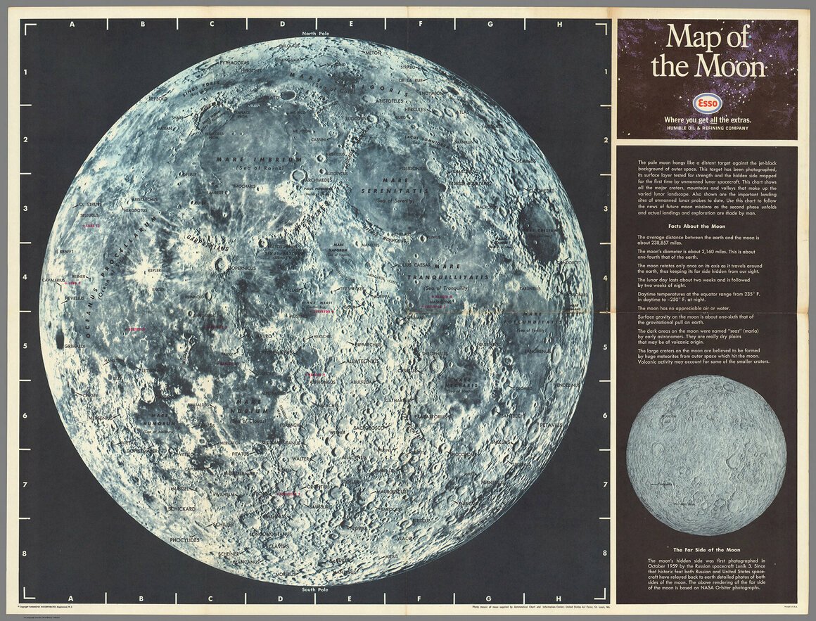
Moon: Near Side
Wingo Epps Circle
Heller Eskey Highway
Rainy Ridge Road
Park Drive
Point View Road
Neil Armstrong Bridge
Road Runner Road
Wile E. Coyote Circle
Princess Leia Parkway (circumnavigates N/S)
Luke Skywalker Highway (circumnavigates E/W)
Gottlieb Road
Shackleton Switchback
Hadley-Apennine Avenue
Aristarchus Plateau Place
Aristarchus Crater Byway
Oceanus Procellarum Bridge
Marius Hills Drive
Reiner Gamma Road

Opportunity's Devilish View from on High. Credits: NASA
Moon: Far Side
Elon Avenue
Robert Henry Lawrence Jr Way
Harrison Schmitt Road
Moon Expressway
Darth Vader Road
OpenStack Lane
Mars
X Æ A-Xii Court
Mark Watney Highway
Ray Bradbury Road
Isaac Asimov Road
House Atreides Boulevard
Lady Jessica Drive
Via Arrakis
Tharsis Cave Loop